Breaking through the bottleneck technique! MapGIS creates a new benchmark for national industrial GIS platform
In the context of the complex and ever-changing international situation, independent and controllable technology has become a key defense line for national strategic security. As a core technology in the field of geographic information, GIS's localization process plays a crucial role in ensuring national geographic information security and promoting the development of the digital economy.
So, as the process of information and innovation substitution enters the core technology breakthrough period, the geographic information industry is facing a critical decision: how to achieve secure and accurate substitution from chips, operating systems to GIS platforms while ensuring business continuity? Zhongdi Digital launches MapGIS national production replacement solution, providing answers with over 30 years of independent innovation accumulation.
Rejecting the 'one size fits all' approach, MapGIS's domestic substitution for precision breakthrough
As a self-developed GIS platform by Zhongdi Digital, MapGIS has completely independent intellectual property rights, realizing independent and controllable control of the entire chain from underlying technology to upper level applications. After more than 30 years of technological accumulation and innovative development, it has become a core force in China's GIS field.
When the wave of innovation swept across various industries, Zhongdi Digital faced the demand for GIS localization replacement in different fields. With the MapGIS platform as the core, it provided mature national GIS localization replacement solutions, derived N industry solutions with a set of independent and controllable kernels, and achieved "customized substitution in different fields", tailoring to the specific needs, making localization replacement truly "stable, fast, and well used".
Four core advantages, reshaping the benchmark of GIS information innovation
Stable environment: a domestically produced ecosystem that is ready to use right out of the box
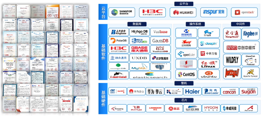
At a time when information security has been elevated to a historical height, we are also actively embracing the innovation ecosystem. MapGIS actively collaborates with upstream and downstream enterprises and has completed compatibility certification with over 50 information and innovation enterprises, building a powerful "whole family bucket" for information and innovation; We have achieved comprehensive support for information technology innovation, including chips, operating systems, complete machines, cloud platforms, databases, middleware, etc. We have also carried out performance optimization work, providing guarantees for the usability, ease of use, and ease of use of information technology innovation GIS.
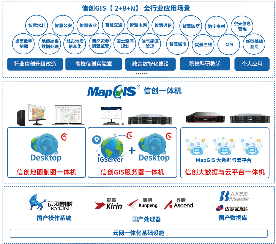
In order to further lower the user's usage threshold, Zhongdi Digital, in conjunction with Kirin and Huawei, has taken the lead in launching a full stack Xinchuang; GIS Integrated machine;. Facing the challenges of adaptation, migration, migration, and deployment, through standardized integration, comprehensive adaptation, and fine tuning, we truly achieve "out of the box" functionality. Users can quickly build Xinchuang without the need for complex adaptation and deployment work; GIS Environment, truly achieving zero threshold transformation. It is not only applicable to the geographic information industry, but also widely used in multiple fields such as smart cities, smart transportation, and smart healthcare, providing strong support for the digital transformation of various industries.
Accurate Data: Comprehensive, Efficient, and Accurate Data Migration Guarantee
Data migration is the core technological challenge for the localization replacement of GIS. The structure of geographic information data is complex, with problems such as multiple versions, diverse formats, and complex types. During the migration process, data loss and accuracy decline are prone to occur. MapGIS has customized a scientific and reasonable migration strategy based on the characteristics of geographic information industry data, and continuously monitors the accuracy and performance changes of business applications after migration to ensure the full, efficient, and accurate migration of data.
● Full data migration: On the one hand, accurately migrate data from non domestic databases to domestic databases; On the other hand, finely converting non localized GIS format spatial data into localized format provides complete data support for business. Ensure complete coverage of various types of data such as file data, attribute data, raster data, 3D data, etc.
●Efficient Data Migration: Provides various data migration tools such as database, file transfer, cloud migration, etc., adapted to different business scenarios and data types. With advanced algorithms and data verification functions, it ensures data integrity and accuracy, efficient operation, and helps smooth business transition.
Accurate data migration: After the data migration is completed, three key nodes are verified, and various professional accuracy verification tools are equipped to verify the accuracy, consistency, and timeliness of the data, ensuring that the data is available, the business is trustworthy, and the management is controllable.
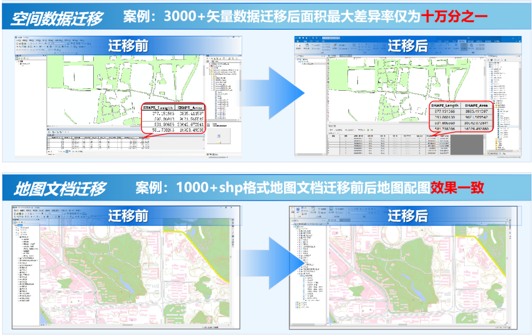
In the case of spatial data migration, the maximum difference rate of the area after 3000+vector data migration is only one in 100000; In the case of map document migration, the consistent mapping effect before and after the migration of 1000+shp format map documents fully demonstrates the accuracy and reliability of MapGIS data migration.
Excellent Performance: Comprehensive Optimization, Significantly Improved Performance
MapGIS implements full stack performance optimization for the information and innovation environment, achieving a leapfrog improvement in performance through kernel reconstruction, architecture upgrades, and technological innovation. After optimization, the performance in all aspects is improved by more than 5-10 times, and the higher the concurrency, the more significant the performance improvement effect. Actual testing shows that the response speed of data spatial queries in the 200000 point line area at the city level has increased by 32%, the response speed of spatial queries for 1.5 million graphic elements has increased by 32%, and the response efficiency of 3D map services has increased by 22% -33%.
Standard process: Three alternative solutions, customized as needed
In order to meet the needs of different users and business scenarios, MapGIS has launched three standard process flows: "layer by layer substitution", "dual track high availability", and "systematic substitution". Users can choose according to their actual situation and needs.
The "layer by layer substitution" is suitable for gradual substitution under a decentralized procurement system, and can be compatible with the ArcGIS ecosystem to achieve seamless connection and smooth transition of business in areas such as natural resources and smart cities;
Systematic substitution "is suitable for new system construction or full stack reconstruction scenarios, and can ensure efficient integration and utilization of data resources and services through unified spatial and non spatial data engine access.
The 'dual track high availability' is suitable for parallel transition periods of multiple businesses. During the transition period, the coexistence of Xinchuang District and non Xinchuang District will not affect the normal use of information systems by users, achieving a seamless application experience.
Application implementation, MapGIS domestic substitution effect is significant
In recent years, Zhongdi Digital has been deeply laying out the GIS ecosystem for information and innovation, achieving numerous breakthroughs. Adhere to the guidance of technical standards, join the Information and Innovation Working Committee, participate in the compilation of industry white papers and technical specifications; Join Xinchuang GIS product evaluation and settle in Hubei Xinchuang Adaptation Base, etc; Xinchuang has achieved fruitful results in key technologies, and its participation in the "Key Technologies and Applications of Autonomous and Controllable High Performance Geographic Information Systems" has won the second prize of the National Science and Technology Progress Award; At the same time, benchmark cases will be implemented in the fields of smart cities and natural resources to support the intelligent construction of provincial and municipal projects.
Participated in the completion of the first provincial-level pilot of the national land space basic information platform - the information and innovation transformation of the Hunan Provincial Land Space Basic Information Platform, providing 248 data services and 519 analysis services to the outside world, with an average daily service call of over 5000. The performance test verification after the transformation shows that the overall performance has been improved by about 10 times.

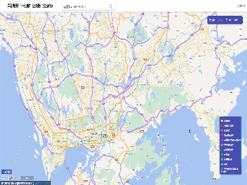
●In the alternative project of heterogeneous GIS platform in Shenzhen, in 2023, the detailed planning map system of ICT Internet version will be launched, with an average daily visit of more than 100000 times, and the GIS performance will be greatly improved; In 2024, the Xinchuang version of the government service approval application system will be launched, supporting the full process online handling of over 260 business approval matters and achieving 5 major capacity improvements.
●Collaborate with Shenzhen Cheng'an Institute to build the Xinchuang Underground Space CIM Platform, deeply participate in the top-level design, policy mechanisms, standard specifications, data exchange, platform construction, and application scenarios of underground spaces, and provide authoritative data sharing services for industry regulatory authorities and ownership units.
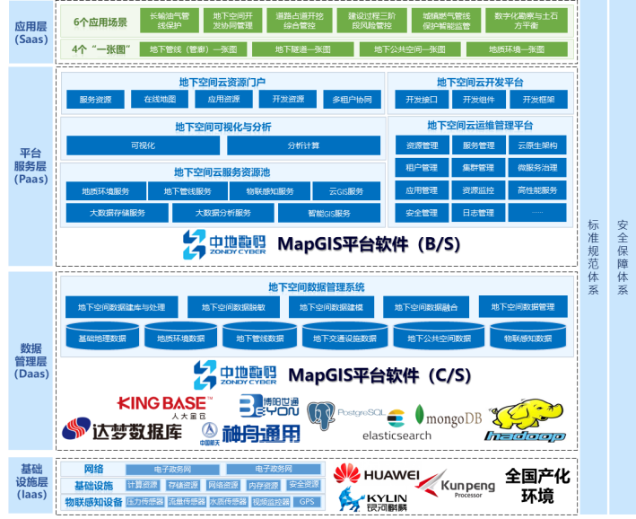
●We have built a nationwide geological and land resources business system in Shanghai, and achieved new breakthroughs in online 3D geological modeling and model rendering technology in the information and innovation environment. We provide a complete solution for underground space data database construction, management, sharing and publishing, efficient visualization, and application analysis, empowering Shanghai's underground space data lifecycle security management.

When the replacement of information and innovation from "multiple-choice questions" to "mandatory questions", MapGIS takes autonomy and controllability as its core, actively exploring the optimal path for the national industrialization transformation of the industry. From technological breakthroughs to ecological integration, from product optimization to application expansion, we are committed to building a full ecological chain "escort system" from underlying chip adaptation to industry application innovation, ensuring that every piece of data is secure and controllable, and committed to continuously injecting strong and sustainable development momentum into the construction of Digital China.


