GIS Intelligent Engine Products: Technological Evolution Empowered by AI Computing Power for Geological Exploration
Since MapCAD revolutionized the history of geological mapping with digital pen strokes, China's geological exploration industry has been pursuing deeper technological breakthroughs. With the wave of AI technology sweeping across the entire industry, Zondy Digital has launched the GIS Zhiying·AI Geological Exploration Supercomputing Station, comprehensively enhancing the technical level of AI application in the geological exploration industry under strong inference models, promoting a leap from "manual experience exploration" to "AI computing power exploration" in China's geological exploration work.
The GIS Zhiying·AI Geological Exploration Supercomputing Station is a DeepSeek training/inference super fusion all-in-one machine built on Huawei hardware platform, deeply adapted to the full-powered version of DeepSeekV3&R1 and its distilled models, achieving a cross-boundary fusion breakthrough between AI large models and geological professional applications. Through six major application scenarios—multimodal geological intelligent Q&A, intelligent 3D geological modeling, intelligent quantitative mineralization prediction, intelligent geological business assistant, drill hole columnar diagram AI recognition, and rock and mineral specimen image recognition assistant—the supercomputing station reconstructs the mode of geological exploration work, equivalent to equipping geological exploration units with an "AI geologist" that works around the clock.
Multimodal Geological Intelligent Q&A
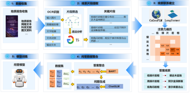
Integrating the T5 model to extract key geological text information, constructing cross-segment attention graphs through CnGeoPLM and Longformer, combining BART to generate answers and DeepSeek to reverse-engineer questions, forming a structured geological Q&A dataset, the trained professional model can achieve precise parsing and service of complex geological reports.


Intelligent 3D Geological Modeling
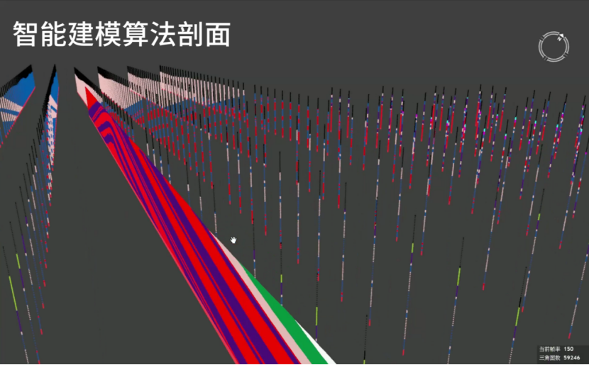
Intelligent 3D geological modeling better utilizes diverse heterogeneous geological data and implicit geological features, solving problems of overfitting and poor anisotropic expression, assisting in lithology and structural form prediction. Compared to traditional geological modeling methods, it achieves improvements in modeling efficiency and accuracy.


Intelligent Quantitative Mineralization Prediction
Centered around multi-scale, 2D/3D intelligent mineral exploration business needs, developing integrated applications of geological mineral exploration knowledge, data, algorithms, and models, providing exploration personnel with an open, comprehensive, authoritative, and full-process intelligent prediction and evaluation working environment.

Intelligent Geological Business Assistant
Through natural language interaction parsing, achieving precise semantic mapping of geological professional terms and spatial elements, utilizing intelligent reasoning engines to invoke 3D spatial analysis operators, automatically generating structured geological assessment reports, parametric thematic maps, and interactive 3D geological model analysis results according to industry standards and specifications.

Drill Hole Columnar Diagram AI Recognition
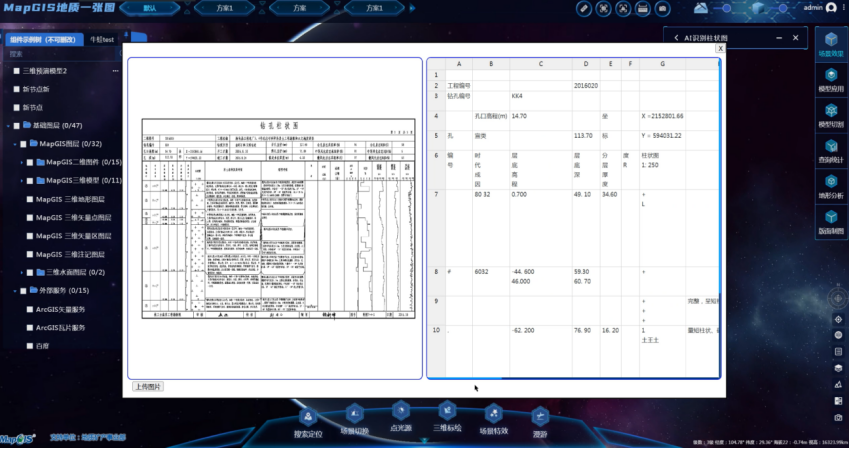
Based on deep learning and image semantic segmentation algorithms, constructing a multimodal parsing model for drill hole columnar diagrams, achieving intelligent recognition and structured output of core geological elements such as stratigraphic lithology, thickness, and contact relationships in drill hole columnar diagrams. Compared to traditional manual interpretation, efficiency is improved by more than 20 times, with recognition accuracy reaching professional engineer levels.

Rock and Mineral Specimen Image Recognition Assistant
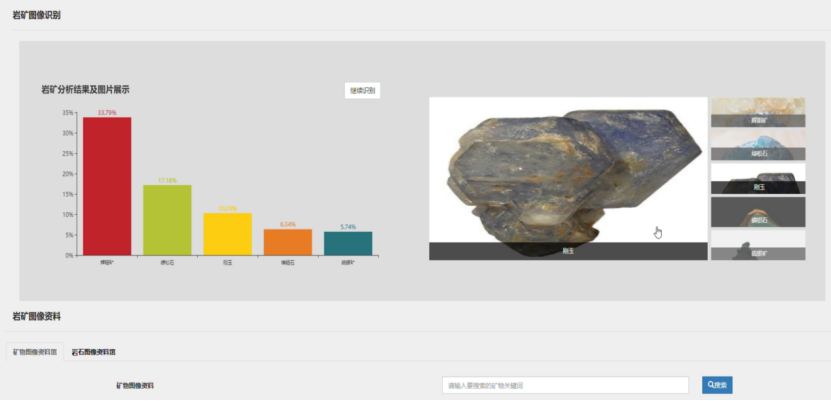
Based on deep learning algorithms, automatically extracting texture, color, and structural features of rock and mineral specimens, finely describing multidimensional information such as rock and mineral types and mineral compositions from a geological worker's perspective, with accuracy rates above 95%, supporting field exploration and laboratory identification??.

From MapCAD ending the history of manual mapping in the geological field, to the GIS Zhiying·AI Geological Exploration Supercomputing Station opening a new chapter in "AI computing power exploration," Zondy Digital has not only reshaped traditional geological work modes but also promoted the industry's leapfrog development at a strategic level. Standing at the new starting point of digital geology, Zondy Digital is using GIS Zhiying as a bridge to transform AI computing power into the key to exploring crustal treasures.


