


Good news | Zhongdi Digital has been selected as one of the top 100 brand software companies in the three provinces of central Hubei, Hunan, and Henan
Recently, the Hubei Software Industry Conference and Optics Valley Software Industry Summit Forum were successfully held in Wuhan. The conference aims to promote the high-quality integrated development of the software industry in the three central provinces of Hubei, Hunan, and Henan, and has released a list of 100 brand software enterprises in the three central provinces of Hubei, Hunan, and Henan by 2025. Wuhan Zhongdi Digital Technology Co., Ltd., with its outstanding contributions and technological innovation capabilities in the field of GIS, has been successfully selected for this list and has become a highly anticipated focus. Wuhan Zhongdi Digital Technology Co., Ltd. has been dedicated to the research and application of GIS technology since its establishment. The company has a research and development team composed of industry experts and senior technical personnel, dedicated to the GIS platform ..
Building a new digital infrastructure for low altitude economy, empowering the full scenario innovation of smart airspace
When the city skyline is illuminated by drone logistics networks, and when the emergency rescue system is restructured with low altitude aircraft, an industrial revolution extending from a height of thousands of meters is accelerating. As a strategic emerging industry in global competition, the low altitude economy is not only a spatial expansion in transportation, but also a super track for the deep integration of digital technology, aerospace technology, and the real economy. As a leading enterprise in China's geographic information industry, Zhongdi Digital has built an integrated low altitude digital infrastructure system of "perception decision-making control service" with MapGIS full space intelligent platform as the core, providing efficient utilization of airspace resources, comprehensive guarantee of flight safety, and response ..

From "civil defense" to "intelligent defense", MapGIS digital base reconstructs coastal disaster prevention ecology
When the typhoon carries rainstorm over the coast of the East China Sea, this beautiful city inlaid between mountains and sea is always racing against an invisible battle. Linhai, this beautiful coastal city, although picturesque, often faces the threat of typhoons and geological disasters. When will hidden dangers strike, how to predict risks, and how to respond to disasters have always been governance challenges hanging over this coastal city. When traditional geological disaster prevention and control methods face many pain points such as long modeling cycles, low warning accuracy, and slow emergency mapping, the Natural Resources and Planning Bureau of Linhai City has joined hands with Zhongdi Digital to jointly explore ..

GIS Map Engine Series Products: The Dual Revolution of Domestic GIS from Security to Efficiency
Faced with the "bottleneck" dilemma in the field of geographic information and the information security challenges of digital transformation, Zhongdi Digital and Huawei have deeply integrated their technical genes and broken through the situation with their hardcore strength - the National Production GIS Map Engine series products have been released, creating an independent and controllable geographic information base for thousands of industries.

Xinchuang Building Foundation · AI Intelligent Transformation, Zhongdi Digital held a grand GIS Dual Engine New Product Release and Partner Conference
On March 26th, the "GIS Dual Engine New Product Launch and Partner Conference" with the theme of "Independent Innovation · Space Breakthrough" was grandly held. Zhongdi Digital and Huawei have deeply integrated their technological genes and launched revolutionary products in the field of information and innovation GIS - the National Production GIS Map Engine and GIS Intelligent Engine series products, attracting more than 300 partners and industry experts from across the country to attend, witnessing a crucial step for China's spatial information industry to move towards full stack information and intelligence.
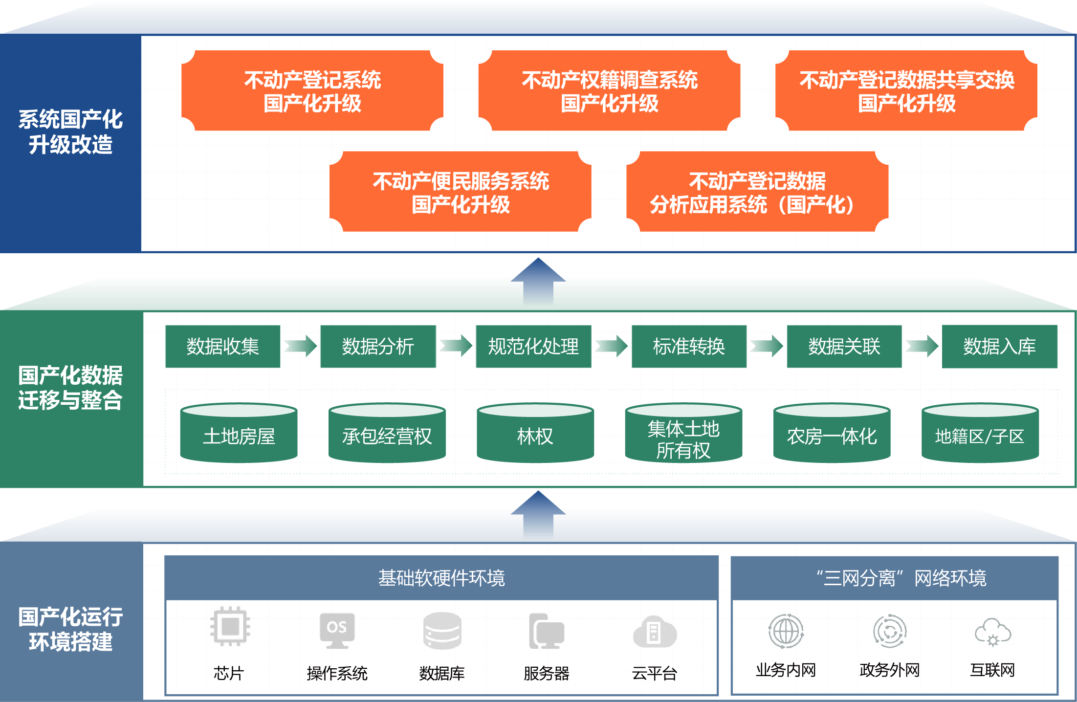
Innovation leads innovation and innovation escorts: localization transformation and upgrading of MapGIS real estate registration system
With the acceleration of China's digitalization process, the upgrading of information and innovation technology across the entire industry chain and industry has entered a decisive period of construction. Real estate registration involves social welfare and information security, and is a crucial part of implementing the national information and innovation strategy. In response to the overall deployment of the "Overall Plan for Enhancing the Digital Governance Capability of Natural Resources" and to meet the higher demands of the people for government information services, the localization and upgrading of the real estate registration management system has been comprehensively accelerated. The MapGIS real estate registration system integrates new technologies such as AI and big data by fully adapting to the software and hardware of national industrialization, and constructs a "data connectivity, field


