


NRSMA
Integrating natural and cultural elements of the ocean, gathering ocean monitoring data, ocean observation data, forecast and early warning data, and historical ocean disaster data,
Build an integrated regional marine stereo observation network and intelligent, grid-based early warning and forecasting system for sky, air, shore, and sea, comprehensively enhancing the capabilities of dynamic marine resource monitoring, situational awareness, comprehensive supervision, and scientific decision-making, supporting scientific and efficient decision-making by marine planning and management departments.
Solution Value:

Solution Content:
Integrated Management of Marine Monitoring Data
Based on the aggregation of marine monitoring data, it provides unified management of marine observation and forecasting monitoring data, sea area use monitoring data, marine economic operation monitoring data, and marine ecological resource monitoring data, comprehensively displaying various types of marine monitoring data to achieve integrated browsing and dynamic display of marine data.

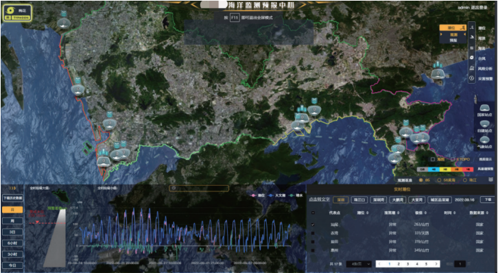
Observation and Forecasting Data Resource Analysis
Observation data comes from various monitoring facilities such as tide stations, wave buoys, comprehensive buoys, ground wave radars, and warning tide markers, as well as shared data from meteorological bureaus, environmental monitoring centers, and the State Oceanic Administration. It can assist staff in quickly and conveniently viewing the real-time data access status of specific facilities, and retrieving, displaying, and analyzing historical forecast data.

Analysis of Marine Biology Survey Field Data
Marine biology survey field data comes from ecological trend surveys, typical marine ecosystem surveys, marine ecological special surveys, and marine ecological disaster surveys, including indicator data such as marine organisms, marine hydro-meteorology, marine water quality environment, and marine biological communities. Through analysis of marine biology survey field data, decision support is provided for marine ecological planning and ecological protection.

Observation and Forecasting Visualization Expression
Comprehensively express various information such as marine tide, wave, current, and typhoon observation, forecasting, and early warning data, as well as natural geographic data, through dynamic and intuitive display, comprehensive querying, and comprehensive analysis, enabling staff to real-time grasp changes in marine observation, forecasting, and early warning information.

Marine Monitoring and Forecasting Center
By analyzing historical typhoons and similar typhoons, discover tide level changes and wave changes in typhoon-affected sea areas; through statistics on historical disaster points, disaster situations, and special reports and early warnings of storm surges and waves, provide marine early warning and disaster prevention support to ensure smooth marine disaster prevention and mitigation work.
Typical Cases:
GuangdongProvince Smart Natural Resources - Marine Data Governance and Application Development Project
Shenzhen Marine Monitoring Data Management and Sea Temperature and Current Fine Grid Forecasting System Project
Related Software
NRSMA
NRSDMS
- Natural Resource Asset Management Solution
- Intelligent Disaster Management Solution
- Solution for Urban Physical Examination Evaluation Information
- Implementation Supervision Information Solution for the "One Map" of National Spatial Planning
- Solution for Land Space Use Control and Supervision
- Green Mining Intelligent Solution


