NRSDMS
For natural resource rights management departments and investigation and monitoring units, Zhongdi Digital has developed a national owned natural resource asset management information system based on the MapGIS platform.
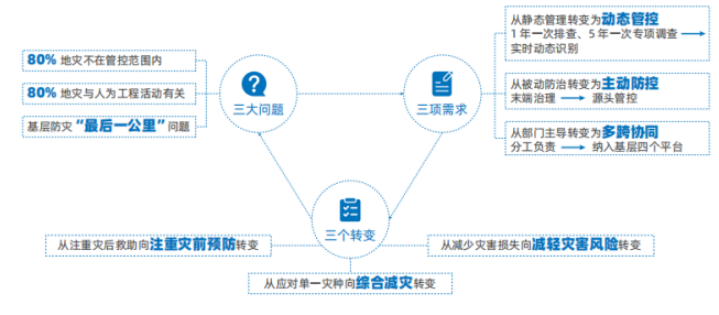
Using new technologies such as digital twins, big data, and artificial intelligence, the system constructs scenarios including risk identification, source control, monitoring and early warning, collaborative disposal, duty management, engineering governance, simulation modeling, and mobile prevention and control to achieve closed-loop management of geological disaster prevention and control business.
Product Value:

Product Highlights:

Construction Content:
1. Risk Identification
For suspected risks discovered through patrols or reported by the public, the system associates territorial spatial information to conduct risk assessment. Meanwhile, based on geological disaster risk survey and evaluation results, it associates landslide surfaces, geological environments, rural housing, and other geological disaster influencing factor information to actively perceive suspected risks throughout the region. After field verification and expert assessment, the system further determines risk conditions and levels, and pushes risk information to relevant departments and towns/villages for disposal, achieving closed-loop management.

2. Source Control
For engineering projects that may cause secondary geological disasters, such as comprehensive land consolidation throughout the region, high-standard farmland construction, and slope cutting for housing construction, the system conducts multi-factor analysis and risk assessment to intervene in advance during the project initiation and planning stages. It analyzes project compliance and the impact of engineering on surrounding geology to prevent and resolve risks from the source.

3. Monitoring and Early Warning
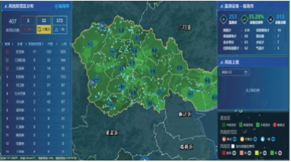
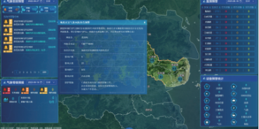
Associating multi-source data including meteorological early warning notifications, real-time IoT sensing, and historical observations, the system uses digital twin technology for simulation modeling. Through analysis and assessment, it accurately identifies geological disaster risks in time and space dimensions, and precisely pushes early warning information to people in risk areas and collaborative departments such as transportation and tourism and culture, empowering advance perception of geological disasters.

4. Collaborative Disposal
Supporting the creation, assignment, and tracking of disposal information for patrol tasks including daily patrols, reporting patrols, monitoring early warning patrols, and meteorological early warning patrols, as well as emergency investigations and rapid reporting tasks for disaster risks. The system displays pending and processed tasks in list form and allows users to view the workflow and details of each task. It also aggregates information of community monitoring personnel and professional technical staff, and checks their on-duty status.

5. Duty Management
Accessing meteorological level early warning, monitoring equipment early warning, rainfall and other data, the system provides functions such as daily reports, rapid reports, duty scheduling, collaborative consultation, and community monitoring personnel management. It facilitates users in timely receiving early warning messages and rapid reporting processes to quickly control risks, understand situations, and make dispositions.

6. Engineering Governance
Tracking engineering governance projects in risk prevention areas throughout their lifecycle, real-time integrating relevant engineering governance information to achieve full traceability and effective control of risk hazard governance, observation, and write-off processes.

7. Simulation Modeling
Based on 3D model analysis and leveraging full-time-space simulation modeling technology, the system accurately simulates the occurrence and development process of geological disasters such as landslides and collapses, as well as rescue activities, providing decision-making references for geological disaster prevention and control.

8. Mobile Disaster Prevention
Applicable to Six level linkage management at provincial, municipal, county, township, village, and group levels, providing business management, professional technical personnel, and community monitoring versions according to different user work needs, achieving closed-loop management of business processes from geological disaster data collection, transmission, management, analysis, early warning and forecasting, problem feedback, to information push and release.

Application Cases:
Linhai City Digital Territorial Space "Geological Disaster Intelligent Governance" Application Scenario Construction
In accordance with the provincial requirements for comprehensive digital platform for spatial governance and pilot requirements for geological disaster intelligent governance and digital twin application construction, Linhai City has established local digital twin, prediction and early warning featured sub-scenes, achieving closed-loop management of the entire chain of business including risk identification, monitoring and early warning, and collaborative disposal. Taking Kuocang and Baishuiyang, two towns with high geological disaster risks, as research areas, the city conducted exploratory research on shallow landslide early warning models, achieving local personalized real-time early warning applications and improving prediction and early warning assessment capabilities.
Related Software
NRSMA
NRSDMS
- Natural Resource Asset Management Solution
- Intelligent Disaster Management Solution
- Solution for Urban Physical Examination Evaluation Information
- Implementation Supervision Information Solution for the "One Map" of National Spatial Planning
- Solution for Land Space Use Control and Supervision
- Green Mining Intelligent Solution


